 |
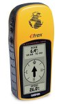
Garmin eTrex GPS
ISBN:
Release Date: 17 March,
2003
Manufacturer: Garmin
Availability:
Usually dispatched within 24 hours
 Sales Rank:
845 Sales Rank:
845
Average Rating: 4.75
Our Price:
£109.99
|
| User
Reviews: |
Garmin etrex
Don't let the fact that this is a bottom of
the range model fool you. It has most of what
you could want. The map facilities on the higher
range models are pretty basic unless you buy
some expensive Garmin software and then the
screens are pretty small for any detail and you
do not get Ordnance Survey like definition
anyway. Do you need a barometer? or an
electronic compass?
The fact is it works
pretty well. One thing the basic manual does not
stress is that at the begining of a hike leave
it to settle and collect as much data as it can.
Takes about three minutes. It needs to lock on
the satellites and after this it needs to
download the relevant data on each one. If you
start moving straight away the download is
interupted and you may only lock onto 5 instead
11 satellites. It will work but the whole point
of a 12 channel receiver is that it will pick
the best combination of what's available in its
system for the most accurate result. The more
the better. Also moving around cover or trees as
you lose one satellite it locks onto the next
best. I have read stories of people losing track
in dense cover but this has to be caused by
failing to aquire enough data at the start of
the walk. The only time I have lost a signal was
in very dense forestry. The cover was so thick
it was really dark. Tall trees obsuring the sky?
no problem, it works.
Regards accuracey?
Well some pay extra for WAAS. Fact is WAAS is
only working in the USA. If you enable WAAS on a
more expensive receiver and pick up a signal it
is actually less accurate. EGNOS should be
coming on stream soon which is the European
version. This will give you a 95% chance of a 3m
accurate fix. Currently we are looking at 95%
chance of a 5m fix. The high definition OS maps
work to a scale of 25m to the millmeter so you
are accurate to a fifth of a millimeter on a map
if you can resolve that fine.
If you can read
this you have a computer so spend about £10 on a
PC connection cable for the etrex, (ebay folks),
and download GPSU from its home page. You can
scan in maps to your PC and position routes and
wapoints on the PC map to an accuracey of about
2-3m. You then download these to the etrex and
you are set. You also get bearings sector and
route lengths. I keyed in path junctions as
waypoints and found that I ended up maybe on one
side of the road but never off it.
At the
end I emerged maybe 60m from the planned
waypoint and thought "hah not that good". I
walked to my planned waypoint and realised that
the old path had been changed and I had walked
the last 100m on the new one! One local was
stunned that I managed 4 miles in thick forest
Didn't tell him I had an etrex.
After the
hike you can download the track from the etrex
and see where you wandered off route, average
speed between trackpoints and position. Also you
can put either time or distance markers on the
route!
You can print this lot out,
maps,routes, lists of waypoints with summaries
for each and so on. This means you can keep the
etrex memory clean. I have a set of motorway
junctions then I upload and download as
necessary. Another set for one walk in
Shropshire and another for London. GPSU is
freeware but you might choose to upgrade and it
works the same on the etrex as it does with any
other GPS. why pay more?
In short its a
cracking little GPS and is pocket size so tucks
away nicely. Most people think you are getting a
text message on a mobile so you are not that
conspicuous.
All GPS's eat batteries. Get a
charger and some Nimh's. These will last about
ten hours. For critical applications take at
least two to three spare sets. Some rechargables
run down after time or just will not hold a
charge. Dont find that out on Snowdon. Duracells
last longer and are reliable but are gone with
one use. Take at least one set of emergency only
Duracells in the mountains. Oh and buy Mike
Leathams GPS book here. It's really really good.
Safe walking.
Best new toy I've bought this year
If
you are interested in a (non-mapping) GPS this
is a top item.
Small with quality feel.
Excellent battery hatch (previously bought
another brand GPS at twice the price and the
hatch was so poorly made I immediately got on
the phone for a refund). Do however buy the soft
Garmin case to protect the screen from scuffs.
Software easy to use but take the full manual
with you first few outings to get to grips with
it quickly..after that is straightforward. I use
mine for measuring running routes and weekend
rambles with the kids. Gives lots of really
useful times/distances/speeds and updates very
frequently...finding more fun in this than I
expected. If you like getting out and about on
foot or in a vehicle this is a brilliant gadget
to take with you...100% recommmended.
Gadget of the year!
5 Stars, says it
all. This is a great peice of kit for
anyone.
I have used it on 4 continents and it
has never let me down. Ease of use, solid
construction and a bomber OS make this a great
peice of kit. It is also exceptional value for
money after all, knowing where you are can be
the difference between life and death. I hardly
leave the house without it.
| |
Similar
Items:

GPS: The Easy Way

GPS Made Easy

Sony AA Size 8pk Alkaline
batteries

Sony AA Size 4pk Premium Alkaline
Batteries

A GPS User Manual: Working with
Garmin Receivers

eXpansys USB - Serial Cable

Canon Photo Magenta ink tank
BCI6PM

Canon Photo Cyan ink tank
BCI6PC

Girl With A Pearl Earring
[2004]

Bytestor USB 2.0 Pen Drive
256MB
|