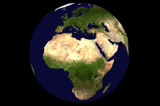
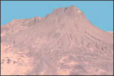
National Aeronautics and Space Administration
Learning Technologies World Wind 1.2

News

  • March 29, 2005
    World Wind 1.3.1 released

  • March 2, 2005
    World Wind 1.3 released

  • January 26, 2005
    World Wind 1.2e released

  • November 24, 2004
    World Wind 1.2d released

  • October 8, 2004
    World Wind full installer

  • New Add-on section archives World Wind cached data.

  • October 5, 2004
    1.2c: Terrain cache, configurable cache size and directory, default web browser, limited proxy support, & Rapid Fire MODIS stability.

  • September 27, 2004
    Due to a large user increase, certain features of World Wind may load slowly.

  • September 17, 2004
    Update: USGS 1m photo, USGS topo map data, tool bar, place name update, & misc fixes. Please uninstall previous version.

  • September 7, 2004
    Update: MODIS fix & patches

  • September 1 , 2004
    Patch: Internationalization bug and speed boost

  • August 29, 2004
    Update: Political boundary fix

  • August 20, 2004
    Update: "White Box" bug with budget video cards fixed.

  • August 10, 2004
    World Wind web site announced

  • August 6, 2004
    World Wind 1.2 released
 
Presentation Kit:
Preparing to demonstrate World Wind? You can download screen shots (here).


World Wind lets you zoom from satellite altitude into any place on Earth. Leveraging Landsat satellite imagery and Shuttle Radar Topography Mission data, World Wind lets you experience Earth terrain in visually rich 3D, just as if you were really there.

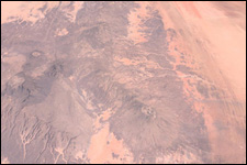
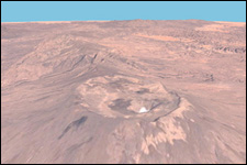
Virtually visit any place in the world. Look across the Andes, into the Grand Canyon, over the Alps, or along the African Sahara.


  Features Features   Download Download  
   
3D Engine
Blue Marble
Landsat 7
SRTM
MODIS
GLOBE
Landmark Set
   
   
World Wind 1.3
Recommended Specifications
Notes
Updates
   
 
  Screenshots Screenshots   Forum Forum  
   
Samples
   
   
Announcements
General
Bug Reports
Support
Suggestions
   
 
  FAQ F.A.Q.   Manual Manual  
   
Frequently Asked Questions
   
   
Introduction
Key Chart
   
 
  Add-on Packs   Press World Wind in the News  
   
These packs add data to World Wind. For use while the server is offline.
   
   
See what others are saying about World Wind.
   
 
  Contact Us Contact Us      
   
Feedback
Development team


Open Source
NASA has released World Wind as an open source program to improve its quality through peer review, maximize awareness and impact of NASA research, and increase dissemination of World Wind in support of NASA's mission: To inspire the next generation of explorers ... as only NASA can.

NASA Learning Technologies
NASA Learning Technologies is a NASA R&D effort for the engineering of teaching tools that deliver NASA content in the most engaging and dynamic manner possible. NASA LT builds the pipeline and the delivery point for unencumbered access to the best data NASA has to provide.

   
  World Wind is developed at NASA Ames Research Center by Chris Maxwell, Randy Kim, Tom Gaskins, Jessica Gan and project manager Patrick Hogan.  
             
Editor: Randolph Kim
NASA Official: Patrick Hogan
Last Updated: 3/29/2005
 
.
The Earth at 10,000,000 m away over Africa

The Earth at 800,000 m away over Emi Koussi

The Earth at 300,000m over Emi Koussi
The Earth at 45,000m over Emi Koussi
HomeFeaturesScreen ShotsDownloadManualContact Us