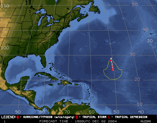
Tropical Depression
OTTO
Latest NCEP/Tropical Prediction Center (TPC) Forecast Positions
   Saffir-Simpson      Max. Sustained          Minimum Sfc.
       Scale       Wind Speed (mph) [knots]    Pressure (mb)
         1             74- 95    [ 64- 83]        >= 980
         2             96-110    [ 84- 96]       979-965
         3            111-130    [ 97-113]       964-945
         4            131-155    [114-135]       944-920
         5             > 156     [ > 135 ]         < 920
The image above depicts the latest NCEP/TPC forecast positions for the
current Tropical Storm/Hurricane in the North Atlantic (See Disclaimer
below).
Presented are the current position (the large, red Tropical Storm/Hurricane
symbol), intensity (the number within the symbol, as listed above), and forecast
positions for 12, 24, 36, 48, 72, 96 and 120 hours (the small, red symbols).
Track forecast uncertainty (based on NHC 10-year average
forecast track errors (1993-2002), except for the 96 and 120 hour forecasts,
which are 2-year average forecast track errors (2001-2002)), is represented by
the thin yellow line surrounding the white track forecast positions.
The text version corresponding to this figure is presented in the Latest
NCEP/TPC Discussion link in the STORM COVERAGE section.
This product was produced using the Man computer Interactive Data Access
System (McIDAS) at the University of Wisconsin-Madison/Cooperative Institute for
Meteorological Satellite Studies (CIMSS). For more information about McIDAS,
click here. Special
thanks to Rick Kohrs of SSEC for help in producing this product.
Disclaimer : The hurricane track forecasts displayed
here are based on the latest NHC/TPC track forecasts received here at CIMSS, and
may or may not be the most current forecast available from NHC/TPC. CIMSS
provides this product for the general public's viewing, but is not responsible
for its ultimate use in the forecasting of tropical cyclones and/or the use of
public watches/warnings. Concerned customers should confirm these
prognostications with official sources.
Special Images :
Other Images :
(black/white "BD" enhancement)
Storm Centered Infrared Image
| JAVA
Movie (color enhancement)
Storm Centered Water Vapor Image
| JAVA
Movie
Storm Centered Infrared Image
| JAVA
Movie (Band 2) 